Google map

Google map


Google map

Google map


Google map

Google map
| 編號 | 769 |
| 英文名 | Amphip'olis |
| 現代名 | Amphipolis |
| 和合本 | 暗妃波里 |
| 新標點和合本 | 暗妃坡里 |
| 現代中文譯本 | 暗妃坡里 |
| 希伯來文編號 | 無原文編號 |
| 希臘文編號 | 00295 |
| 型態 | 0 |
| 座標 | 地圖 Google map |
| 聖經地名大全 | (Gr.--am-fip'ol-is), a city of Greece, throggh which Paul and Silas passed on their way from Philippi to Thessalonica (Acts xvii:1). It was situated on the left banks of the river Strymon, which flowed around the city, and thus occasioned its name. Its situation upon the banks of a navigable river, a short distance from the sea, with the vicinity of the woods of Kerkine, and the gold mines of Mount Pangaeus, rendered Amphipolis a place of much * importance, and an object of contest between the Thracians, Athenians, Lacedaemonians, and Macedonians, to whom it successively belonged. The Via Egnatia passed through it. It was called in the Middle Ages Popolia (Tafel, Thessal. p. 498f.), and is now represented by a village called Neochori, in Turkish Jenikoei tSee_plan in Leake, N. G. ii:191). Zoilus, the carping critic of Homer, was a -ative, and wrote a history of it in three books (Suidas). |
| 編號 | 提供者 | 位置 | 經緯度 | 時間 | 說明1 | 備註 | 媒體 |
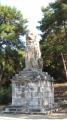
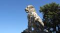
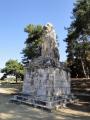
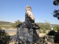
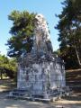
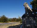
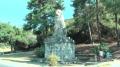
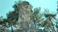
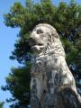
| 621 | lk | 暗妃坡里 | 40.8031,23.8425 Google map | 2011.08.29 | 暗妃波里之獅 | | |
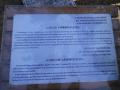
| 665 | rhlu | 暗妃坡里 | 40.80308,23.842537 Google map | 2011.08.29 | 暗妃波里之獅,第1張為說明 | | |
| 1117 | 蔡宛晏 | 暗妃坡里 | 40.80308,23.842537 Google map | 2011.08.29 | 暗妃波里之獅 | | |
| 1118 | 陳錫良 | 暗妃坡里 | 40.80308,23.842537 Google map | 2011.08.29 | 暗妃波里之獅 | | |
| 1119 | 鄧澄欣 | 暗妃坡里 | 40.80308,23.842537 Google map | 2011.08.29 | 暗妃波里之獅 | | |
| 945 | 陳錫良 | 暗妃坡里 | 40.8031,23.8425 Google map | 2011.08.29 | 暗妃波里之獅 | Video1 Video2 Video3 Video4 Video5 Video6 Video7 |